The content of the article:
- 1 MarineTraffic – Online Tracking Service following ships
- 2 How to find a ship by name online at MarineTraffic
- 3 Principles of operation of the AIS system
- 4 Seatracker .ru – Providing Location Information ships online
- 5 Color codes of ships on the map of online services
- 6 How to use the ship chart in real time on Seatracker
MarineTraffic – an online service for tracking the route ships
The site provides information on the whereabouts of ships online. This is a map of the world on which the icons of ships of different colors. Each color indicates type, speed, control method and other information.

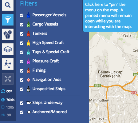
Side menu service
There are icons and icons around the map for management and settings. To the left of the menu are buttons for setting the map, such as: layers, filter, traffic density maps, weather and others. Here you can find ship by name, indicating information in a special field. At By clicking on one of the ships on the map, information appears in the window about:
- Name of the ship.
- The speed at which the ship follows.
- Course. From where and where to.
- Status.
- Type of ship (passenger, tanker, etc.)
When you click on the name of the vessel in the window that opens, it opens more complete page with details of the ship in real time.
How to find a ship by name online at MarineTraffic
If you have some information about what interests you ship, then it will be easy to find. It is necessary:
- Go to the site – https://www.marinetraffic.com/en/.
- In the upper right window titled “Ship / Port” enter your information.
- In the window that appears, click on the name of the vessel or port for detailed information.
By visiting the site you will notice that the information is provided on English language. You can change it by dropping to the bottom of the page and by clicking on “Language”. In the drop-down menu, select Russian.
Ship map online is updated in real time, but you need Be aware that ocean traffic is relatively small. Cause the ship’s “hovering” can also be connected with the system itself, because it is not perfect and has flaws. Although it is being improved from time to time, but there are still areas of the ocean in which the signal disappears. In this case, you must wait for the signal to appear, to continue tracking the ship.
Principles of AIS
Today, in order to ensure safety, all ships have board identification system AIS. She reports whereabouts one or another ship in the ocean and does not allow collisions. The distance at which the ship can move away from ground receiver – almost 400 km. Ground reception system should be above sea level, and the ship system has a powerful signal and high-quality antenna. In this case, visitors can use the services of the service.

Ship Routes
Seatracker.ru – Providing Location Information ships online
Siatracker is a portal for seafarers that provides news and various files, mostly offshore.
By clicking on the link in the top menu “Ais” we get to the political a world map on which ship icons are also located, painted in different colors, depending on the type and purpose. The map menu on the service is a simplified option, relatively MarineTraffic service. Here, on the left in the menu there are only 3 buttons – search, filter and layers. Right 2 buttons for adjusting the reduction or an increase in a mini card. There is a search box above the map ship or port by name.
Color codes of ships on the map of online services
Online ocean charts have the same color coding for the two services listed.
- Blue – passenger ships are marked with this color.
- Green – cargo ships.
- Yellow – a vessel with high speed capabilities.
- Red is a tanker.
- Pink – yachts.
- Orange – fishing boats.
- Blue – Tug.

Ship Route
How to use a ship chart in real time on Seatracker
- On the site https://seatracker.ru/ click on the link above Ais.
- On the map page, you can use the search and enter name of the vessel.
- For convenience, on the left of the menu is the “Filter” button, using it You can choose a vessel by color.
- Here, in the menu on the left there is an icon with layers, selecting which can add or remove ports, station names, lighthouses and images.
All information that is on the site comes from the data AIS. Present stay of the ship, departure from the port and arrival The port may vary by approximately 1 hour. Information online coordinates of all ships provided by the service is fact-finding information and should not be used to navigation.